
NIGERIA: The Federal Government has warned of widespread flooding across Nigeria in 2026, with 14,118 communities in 266 Local Government Areas (LGAs) spanning 33 states and the Federal Capital Territory (FCT) classified as high-risk zones.
The Nigeria Hydrological Services Agency (NiHSA) unveiled its 2026 Annual Flood Outlook (AFO) on Wednesday at the State House Banquet Hall in Abuja. The report predicts that flooding will peak between July and September, coinciding with the height of the rainy season.
Minister of Water Resources and Sanitation, Prof. Joseph Terlumun Utsev, who presented the outlook, listed the high-risk states as: Abia, Adamawa, Anambra, Bauchi, Bayelsa, Benue, Borno, Cross River, Delta, Ebonyi, Edo, Enugu, Gombe, Imo, Jigawa, Kaduna, Kano, Kebbi, Kogi, Kwara, Lagos, Nasarawa, Niger, Ogun, Ondo, Osun, Oyo, Plateau, Rivers, Sokoto, Taraba, Yobe, Zamfara, and the FCT.
Additionally, 15,597 communities in 405 LGAs across 35 states (excluding Ekiti) face moderate flood risk, while 923 communities in 77 LGAs across 24 states fall into the low-risk category.
Urban Centres at Risk
Major urban centres, including Abuja, Lagos, Ibadan, and Port Harcourt, are vulnerable to severe urban flash flooding due to poor drainage systems and intense rainfall. Coastal and riverine states such as Bayelsa, Delta, Rivers, Lagos, and Ogun face additional risks from river overflows and tidal surges.
President Bola Ahmed Tinubu, represented at the event, described flooding as a persistent national challenge that threatens lives, livelihoods, and food security. He emphasised the need for proactive measures and urged a shift toward smarter water resources management as part of Nigeria’s transition from an oil-based to a water-based economy.
The President highlighted ongoing flood control interventions in vulnerable states, including Adamawa, Benue, Kogi, Bayelsa, Rivers, and Delta, noting that such efforts have helped improve agricultural output in recent years.
AI-Integrated Flood Modelling
NiHSA Director-General, Umar Ibrahim Mohammed, said the 2026 outlook incorporates an upgraded hybrid AI-integrated modelling system. This enhances forecast accuracy, reduces false alarms, and provides longer lead times for early warnings. He also announced the transformation of the agency’s flood dashboard into a real-time geo-intelligence platform, supported by a mobile application.
Historical Devastation
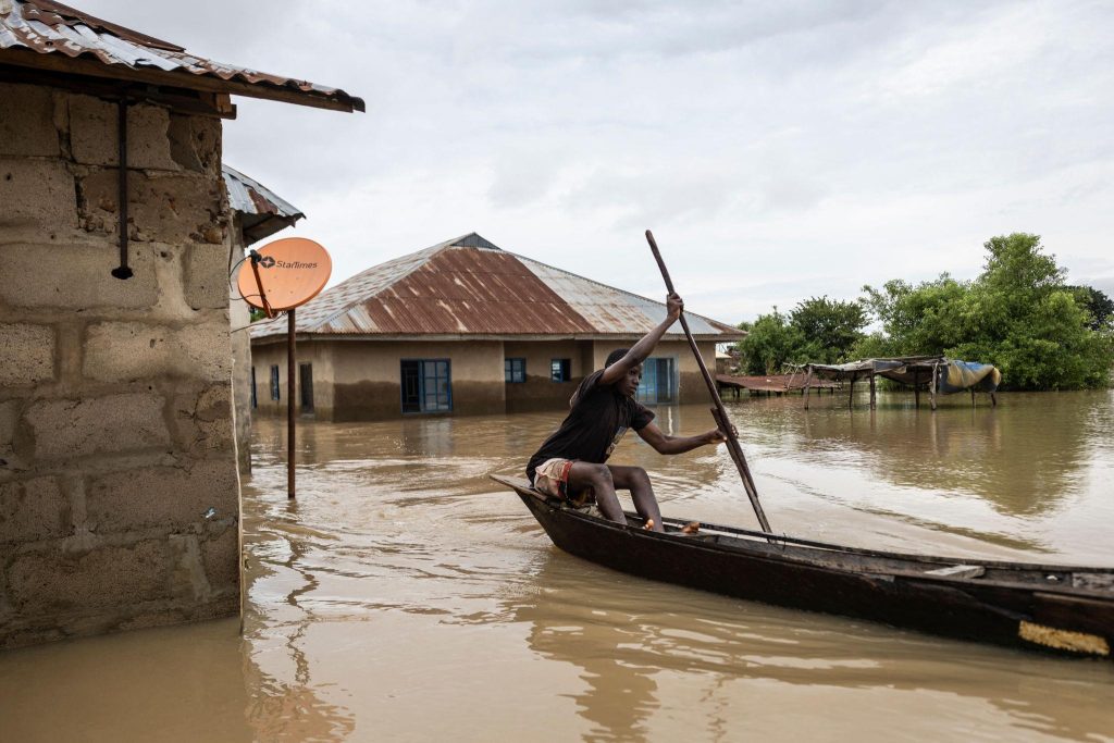
Nigeria has experienced repeated devastating floods in recent years. The 2022 floods — the worst in over a decade — claimed over 600 lives, displaced 1.4 million people, and destroyed hundreds of thousands of hectares of farmland. More recent incidents, including the 2024 flooding in Maiduguri and other areas, have further underscored the ongoing threat.
Call for Action
Authorities are urging state governments, local councils, and residents in flood-prone areas to take immediate preventive steps, including:
- Desilting of waterways, gutters, and drainage channels
- Clearing of illegal structures in floodplains
- Enforcement of building codes
- Preparation of emergency evacuation plans
- Relocation of vulnerable communities where necessary
The full 2026 Annual Flood Outlook report, including detailed state-by-state and LGA mappings, is available on the NiHSA website (nihsa.gov.ng). The agency has also launched a real-time flood intelligence dashboard to support monitoring.
Residents in high-risk areas are advised to remain vigilant as the rainy season approaches and to heed official warnings from NiHSA, the Nigerian Meteorological Agency (NiMet), and the National Emergency Management Agency (NEMA).
The government has stressed that early preparation and coordinated action can significantly reduce the loss of lives and property in the coming months.
Source: Reuters


